This review of the 2014 race course serves as an example for those curious about how a race like this works. Competitors
in the 2018 edition can consider this a representative sample of one of our expedition race courses.
Total canoe paddle distance (approx): 24 miles (blue line on the map below)
Total trek distance (approx): 10 miles (red line on the map below)
Partial Leg 1 map (the first 2/3 of the map):
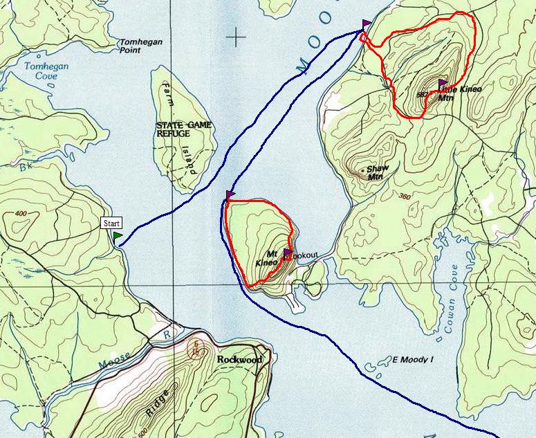
Starting from the beach at The Birches Resort on Moosehead Lake, teams have a quick
"prologue" of orienteering on The Birches property. This will introduce teams to the Maine woods
and let them work off that nervous starting line energy. This is only a quick 30 minute opening section.
After the prologue, teams have a 5 mile canoe paddle northeast across Moosehead Lake. On the Eastern Shore is a
remote campsite that is their destination, and where they will leave their canoes to travel over land to the first mountain
summit on the 2014 race course: Little Kineo Mountain. This summit has a sheer cliff on it's east side, falling 300 feet into the
dense forest below; race teams will rappel down the cliff and into the woods, then visit another checkpoint in the forest on their
return to their canoes.
Teams then have a short paddle to Kineo Island, famous for the imposing cliffs that form the perimeter. Teams will land their canoes on Kineo
Island and complete a trail running circuit up and around the cliffs, approximately 4 miles in total distance. The views from high atop Kineo
Island can be spectacular!

Teams return to their canoes again for the third and final paddle section of Leg 1. This time, it's a 16 mile crossing of
Moosehead Lake. Conditions can be challenging on this stretch of paddling, and teams will have several navigation obstacles to
negotiate with the large number of islands, peninsulas, and bays.
Leg 1 concludes at a private campsite near Lily Bay State Park; this is the "Good To-Go Transition Area" where racers will
be welcomed with a gourmet meal prepared by Good To-Go (creators of innovative camp meals). The hot meal should help
prepare athletes for the rigors of Leg 2.